|
 |
|
There were a number of treaties with the same tribes or bands which were signed at around the same time in Michigan and Wisconsin. The treaties which are critical in current court proceedings involving Mille Lacs band's hunting and fishing rights (decided in favor of Mille Lacs, and being appealed by the state of Minnesota, 9 counties, and various tourist vusinesses) are deiscussed (with maps) and the history of the treaties litigations in Wisconsin and Michigan at: Native American Fishing Rights -- G. Sanger, fish and wildlife expert, who has served in this capacity for Lac Courte Oreilles in the long Voigt lawsuit prepared a number of essays, a treaties page (with maps), a history of non-Indian opposition, and a page of Q and A type misconceptions commonly held about treaties by non-Indians. His whole linked pageset was prepared for a course in Ethics for graduate students of Natural Resources Management at the University of Minnesota in 1996. The treaties below primarily affect land located in what is now Minnesota. I've summarized each of them, and they may be clicked to see the whole treaty and its signatories. Treaties will be pulled from a database -- my link contains the searchcommand -- so it won't be instant. 1825 Prairie du Chien -- Multinational peace treaty, drew line between Chippewa and Sioux. This treaty was not a land cession teaty but a necessary predecessor. It sought to place all tribes in the Great Lakes region within boundaries which would then be considered "their land" (for a short while). The ostensible reason for the treaty was a peace treaty primarily between the Ojibwe and Dakota (though other tribes also signed). In actuality it was to introduce the tribes to the concept of bounded regions of territory. The main content of the treaty was to draw a line dividing Minnesota, Wisconsin and Michigan roughly in half, with Ojibwe territory north of the line, Dakota south of it. Once the concept of "this is your territory, inside the line" had been accepted, the land cessions could begin, and did. Winnebago (Ho-Chunk) TreatiesAlthough no Ho-Chunk reservations remain in Minnesota, in years before the 1800's considerable numbers of the people lived here. For some years a very small Winnebago reservation was maintained in the southeast corner of the state, administered -- like other small, scattered parcels of Winnebago land -- from the BIA's Ashland, Wisconsin, agency. These two treaties ceded all land in Minneswota 1855 treaty with Minnesota Winnebagoes (Ho-Chunk) cedes 900,000 acres land in Minnesota Winnebagoes keep small reservation in southeastern part of state. asdministered from wisconsin. Overview: Minnesota Treaties | |
 |
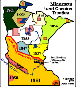
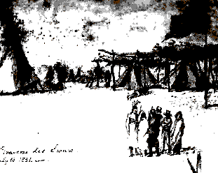
This map focusses on treaties, although for many of them reservations were established -- not entirely where they are today. The orange part is the territory the Dakota (Sioux) accepted in the 1826 peace treaty of Prairie du Chien. The main Dakota cession was the Treaty of Traverse des Sioux, 1851, which in effect ceded almost all Dakota territory except for a strip on the Minnesota River. This treaty -- and the fact that a few years later the Minnesota river north strip was taken -- cost Little Crow (Ta-Oyate-Duta) his reputation with many warriors. Ceded areas are marked with dates of treaties, which are summarized (and linked-to in full) below. |
Sioux (Dakota) Treaties
| |
