|
Click on the numbered reservations to learn about them. Or use the list:
|
|---|
|
|
Click on the numbered reservations to learn about them. Or use the list:
|
|---|
|
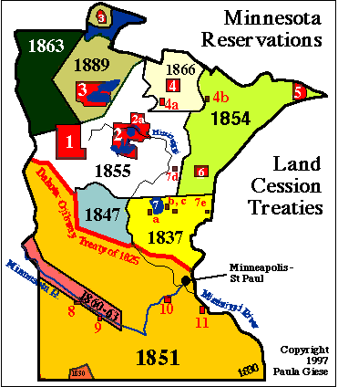
Clicking on either the red number or red area outlining a reservation or the list to the right of the map will bring up a file of current and historical info on that reservation, including noteworthy people and events, as well as land, population, and economic statistics. If there are web pages or sites by/about the tribe, links will be on the info page accessed through this map. Court puts treaty harvest on hold -- April 9 story (with some background) from Minneapolis Star-Tribune's website, today. Look at posted feedback, too, generally expressing hostility to our rights, and "time to do something about it". Flood 97 Situation Reports from Minnesota Department of Emergency Management. situation report for 4/9 says sandbagging volunteers requested for Redwing and the Prairie Island Indian community. Click Prairie Island above, for a picture of the radioactive barrels sitting on a loose concrete slab there, and the nuke. Relevant ones re Prairie Island are #8 and #9 and latest one posted (Friday 4/11) Saturday, saying )at end) some Prairie Island Dakota community homes under water. Nothing about nuke or casks in any situation report, press etc. PGiese rough notes and long & short source docs re Prairie Island Dakota Indian community and the NSP nuke and dry hot casks by it in the floods of april 1997 expected to crest (both Mississippi and Minnesota Rivers) Sunday or Monday, about the same time near lock & dam (i.e. near the nuke and casks). Very rough source material for Indian journos, speculative rough notes from me. Ref to my long article in Akwesasne Notes 1995 fall issue, good backgrounder on situation here. Pix (photos and maps) from Army Corps of Engineers & NSP linked here, some others (casks, nuke) and more info on the Prairie Island page, the above Mnrezmap.html links-to. 74k text, mostly because long source material re chernobyl, which is why I'm posting this at Fond du lac well away from Twin cities in this rough unusable form.
The Midewiwin or Grand Medicine Society of the Ojibway University of Indiana Archives: 1600-1640. These historical documents were mostly compiled for presentation in the unsuccessful attempts of the Miami tribe of Indiana to achieve federal recognition, the University is putting some of this on-line as a library. Some really are old docs transcribed (Jesuit relations), some, like this are 19th-century, should be considered a source of what an observant white man, married to an Indian woman, who lived very briefly among Indians as an Indian Agent, observed and thought. A solid streak of racist contempt for Indian religions runs through this account. Address-phone contacts for all Minnesota, Wisconsin, and Michigan reservations -- federally-recognized only -- may be accessed through a table prepared from the BIA server in Washington. This link brings up the Minneapolis Area Office address and phone contacts listing, (Minneapolis area office is responsible for 3 states: Minnesota, Wisconsin, and Michigan), with table) to official reservation names. The only info is address/phone contacts for the tribal offices (or area office and field agencies. People's names (usually tribal chairperson) are not necessarily up to date. The link list has been regrouped (from the BIA's irrational order) by state. Clicking on Ojibwe or Dakota at the reservations list at the side of the MNrez imagemap will bring up a brief history of the Ojibwe and of the Dakota peoples centering on but not limited to Minnesota. The Ojibwe history includes a biography of Bug-O-Nay-Geeshig (Hole in the Day) and Ta-Oyate-Duta (Little Crow) for Dakota. The sketches were written by Minnesota Wahpeton Dakota Ohiyesa (Dr. Charles A. Eastman) in 1916. For all the linked-to histories and tribal information files, use the BACK key to return to this Minnesota imagemap page, or the page navigation buttons to continue or return to the MAIN MAPS page, or this site's MAIN MENU. |
|---|
| Page |
Menu |
Menu |
|---|
|
Text, maps and graphics copyright -- Paula Giese, 1996. except where elsewhere attributed. CREDITS:I did the map in the mid-1980's from research on treaties and their boundaries done for the American Indian Movement in the mid-1970's.. Last Updated: 4/10/97
|