
 SUNPATH IN THE STARS
SUNPATH IN THE STARS
		Time takes me on its wing and I travel to the sun
			and am consumed by fire.
		Time takes me on its wing and I travel to the river
			and am drowned in water.
		Time takes me on its wing and I travel into the earth
			and am a mountain not yet risen.
		Each place I go others have gone before me.
		That is why
			the sun dances
			the wind weeps
			the river leaps
			and the earth sings.
		Neither the sun nor the wind, the river nor the earth
			did these things
		Before man was placed in this world to believe it.
				--Taos Pueblo sayings
 Earth, the original clock--is shown with its direction of revolution (counter-clockwise), which makes the sun's apparent path and the night sky's apparent motion appear to revolve clockwise when we look "down" on the north pole. The skydome is rising in the east, setting in the west from our individual earth-surface viewpoint. The large earthclock can be saved as a model for a solar clock-dial. Make the ray for the noon sun fixed, fasten both the earth and the time dials to revolve around a center pivot, and make 3 pivoted "hands" for sunrise and sunset time and longitude. You can set this clock, and move its hands to represent times (usually given in local newspapers) of sunrise and sunset at any time of year. Rotating the earth dial will then show day, night, dawn and evening everywhere in the northern hemisphere. Earth, the original clock--is shown with its direction of revolution (counter-clockwise), which makes the sun's apparent path and the night sky's apparent motion appear to revolve clockwise when we look "down" on the north pole. The skydome is rising in the east, setting in the west from our individual earth-surface viewpoint. The large earthclock can be saved as a model for a solar clock-dial. Make the ray for the noon sun fixed, fasten both the earth and the time dials to revolve around a center pivot, and make 3 pivoted "hands" for sunrise and sunset time and longitude. You can set this clock, and move its hands to represent times (usually given in local newspapers) of sunrise and sunset at any time of year. Rotating the earth dial will then show day, night, dawn and evening everywhere in the northern hemisphere.
This clock has been set to my longitude at Minneapolis. At Greenwich solar noon, the current Minneapolis solar time shown is 5:45, sun will rise around 7:30 am when the earth-dial is revolved so Minneapolis is under sunrise. It will set at 4:30 p.m. when the earth-dial has revolved Minneapolis's longitude to the orange sunset ray. It is currently noon on the 0 Meridian, at Greenwich, England. We have to look at a bigger map to see what happens to the sun in relation to the fixed stars during a year. The meridians (longitudes) and parallels (latitudes) are projected from the earth's center and surface onto an imaginary celestial globe that encloses the earth. Using this larger starmap, we'll see in more detail the sun's path among the stars that Lakota elders remember in special constellations that relate to spring-summer ceremonial time. The conventional constellations of ancient astronomy (and astrology) are shown on the maps.
In reality, the earth is revolving in its orbit around the sun. This chart is what the sky looked like to ancient astronomers, and because it looks and feels that way to us, too, the chart is still useful for navigation -- in fact, I re-graphed it from U.S. Navy observational and computational data. You can save it to your local disk (41K GIF file) and print it. This file is in 2-colors for B&W printing. To use within PageMaker or a wordprocessor, convert it to TIF or any format your software likes for graphics (some can use GIF's). This starmap measures a solar year. It has 3 axes. Across the top (north) are sidereal hour-angles (used in navigation) that correspond to hour-circles (meridians) across the bottom, that keep star time. Starting from the 0-point at the vernal equinox at right and left edges, the hour-meridians measure another coordinate of star-location, right ascension. The right and left vertical axes mark parallels in degrees -- these would be latitudes if this were an earth's surface map. On a star map, these angular measures are coordinates of declination, the arc of an imaginary celestial meridian drawn through the poles and the celestial equator, lying between the star and the equator. A measurement of declination corresponds to an angular measure of latitude on earth. At 0� horizontal line is the celestial equator, which crosses the fall equinox axis -- the 180� with 12th-hour vertical. The right and left edges of the chart join at spring equinox. The heavy dashed line is caused by the earth's axial tilt to the plane of the ecliptic, with the sun's apparent path shown along it. Where the sun appears on this path at a certain date, nearby stars won't be visible, because they're in the day sky. The sun is said to be "in" those 12 constellations (called the zodiac) that lie close to the ecliptical sun path. Solstices are at the 270� (summer) and 90� (winter) vertical hour-meridian-lines. Dates for the sunpath are in small italics. Constellation NAMES are in caps. Starnames of very bright stars are also shown. Of course many stars are not shown, and star sizes are greatly exaggerated. Lakota key stars for the Great Circle-Black Hills (Pleides, Rigel, Sirius, Procyon, Castor-Pollux, Capella), the Animal constellation (Sirius, Orion's belt, Rigel, Betelgeuse, Pleides), Mato Tipila (Gemini), and Dried Willow (Triangulum, Aries). This is a section from the large starmap, plotted with current data, so it shows the sun's path (and dates within the constellations) as they are at present, not as they were 2,000 years ago, when the sun was in Aries on March 21, the vernal equinox, to establish the beginning of the spring ceremonies. You can compare it with the Lakota starmap shown earlier here. Use the BACK key to return. |
|---|
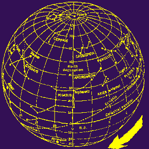 | A rectangular map distorts the skies at the north and south (as a flat map does the land). This spherical celestial map wraps the flat star map around a globe (imagine earth centered inside it). Right and left edges of the flat starmap (vernal equinox) are joined down the middle of this globe at the 0 - 24 hour mark, the beginning (0) and end (24) of the solar year, as the cycle repeats. Pegasus is left of the join, Andromeda right |
|---|
|
The centerline of my flat starmap is on the back of its globe. The dashed line of the ecliptic plane moves down to the southern hemisphere after crossing the vernal equinox meridian in the center, here. Most of the Lakota Animal constallation (Sirius through Orion, Taurus) hasn't risen yet as the earth (imagined in the center of this celestial globe) revolves. We can see the Pleides near the ecliptic at the right. Triangulum and Aries (Lakota: Dried Willow) are toward the middle. Each meridian (great circle passing through the poles) is an hour-circle. It represents the sky's revolution through 15�, 1 hour's time (24 hours x 15 = 360�, a full revolution, 1 day). Notice that the celestial globe rotates clockwise (seen from the north). Think of the earth located at its center -- earth really, physically rotates counter-clockwise seen from north of the plane of the ecliptic, so we see the sun and stars rise in the east and set in the west. If the celestial globe rotated and the centered earth did not (as the ancients thought), its direction would be as I've shown. The apparent clockwise direction of the celestial globe's rotation is the reason the hands on our clocks revolve the way they do -- clockwise was established by the stars, for early clockmakers. Though we now know that this conception of the earth in the center of a celestial globe of stars (with other transparent globes containing sun, moon, planets), is not physically true, it is still a convenient model for astronomical star locations, and for navigation. In order for the long-ago Lakota astronomers to have had the concept of the sun moving progressively through invisible constellations in the day-sky, they must have conceived a model like this, as did the ancient astronomers of the Mediterranean, Orient, and South America. The invaders who contacted and destroyed the indigenous cultures, and the anthros who studied them for centuries, were not linguistically or scientifically able to understand Lakota astronomy, which would not have been widespread common knowledge anyway, so it nearly passed away, unnoticed. The celestial globe model is not in the Sinte Gleshka book, probably because those few elders who remember scraps of the old star knowledge now have it by rote in relation to ceremonial activities, not by close observation and theory, the way it had to have been discovered and conceived by Lakota ancients. Below, we take a look at details from the large flat starmap on 4 crucial dates: the 2 equinoxes and the 2 solstices, and finally compare the modern sunpath in zodiac constellations with the ancient one to see the changes caused by precession over 2,000+ years. |
|---|
| Near the right edge of the starmap -- the vernal (spring) equinox, beginning of the solar year. This section of the starmap shows the sun's position nowadays at vernal (spring) equinox now -- with the sun in Pisces. It arrives in the Dried Willow Lakota constellation (Ares, the Ram plus Triangulum) a month late, April 22. You can see the lower part of Dried Willow, with its brightest star (Hamal) in Ares. Days are longer than nights from now until fall equinox. | 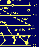 |
|---|
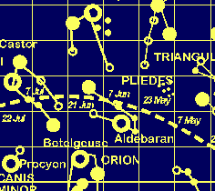 | Around June 21 (summer solstice), the sun nowadays is leaving Taurus (part of the Lakota Animal constellation) and heading for Gemini (Lakota Mato Tipila, Devil's Tower). It's still running a month behind the ancient Lakota star observations that set a Sun Dance for this date, after a ceremonial round that began with the vernal equinox. Summer solstice is the longest day of the year. |
|---|
| Fall equinox occurs around September 21. The sunpath is crossing the celestial equator (as it does at both equinoxes), about to enter the constellation Virgo, the Virgin, having left its late summer constellation Leo. Day and night are (as in spring) once more equal in length. From now until winter solstice, days will shorten and nights lengthen. | 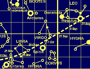 |
|---|
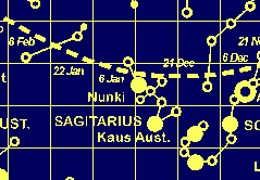 | Winter solstice on the starmap shows the shortest day of the year around December 21. The sun is in the constellation of Sagittarius, the Archer. From now on, the days will continue to lengthen, until, at midsummer solstice around June 21, they begin to shorten again. |
|---|
|
I have previously shown how the precession of the equinoxes, the 26,000-year cycle through which the earth's polar axis sweeps a double-cone in the sky, changes the sun's apparent path through the stars as the earth's rotational axis changes orientations over long periods of time. The astrological constellations of the zodiac, and their relation to the sun's path over a year were known more than 2,000 years ago (about the time the Lakota star-determined ceremonial times must have been established). This chart shows the time relationship of the old constellation-positions (which are still used as astrological birth-signs) to the present-day ones. My "sign"(according to those newspaper horoscopes) is Taurus. But in reality, on my birthdate, the sun was just entering the Pleides (not an astrological constellation). So all those birth-date horoscopes are a month off. If you're a fan of those little newspaper horoscopes, maybe you should try reading the one given for the month after your birth! But . . . it's not exactly even months. Because star time differs slightly from sun time, the sun is "fast" for most of April, May, and about half of June; and again most of September, October, November, and most of December; the other months (and parts) it's slow. The 17th century English poet John Donne was unhappy with abandonment (as he thought) of the enclosing, starry globe -- which is how our unaided senses perceive the cosmos -- for the sun-centered solar system of Newtonian physics, just then coming into scientific acceptance. He used the death of an otherwise-forgotten nobleman as a metaphor for everything he felt was wrong with the Age of Reason, in a long epitaph-poem for the death of something he could not describe:
|
|---|

Custom Search
|
solstice |
Menu |
MENU |
|---|
Page prepared by Paula Giese , text and graphics c. 1995, 1996
CREDITS: The big star chart was graphed in FreeHand from U.S. Navy Oceanograpic Office Chart No. 2100 (1960), then converted to a raster image. The old-and-modern zodiac diagram was made by combining the Navy sunpath data with astrological "sign" dates given in modern horoscopes which use the ancient star positions. The poem at the outset was compiled from aphorisms and sayings of Taos Pueblo people over a 10-year period when Nancy Wood visited among them and wrote a Sierra Club book about their struggle to gain the return of their sacred Blue Lake. The book is Hollering Sun, Wood, Simon and Schuster, NY: 1972. I drew the star-quilt pattern. Clayton Brascoupe (Mohawk) drew the sky-spirit in black and white for Akwesasne Notes in 1974; I traced and colored it in FreeHand as part of a project to save Notes' graphics from its great period and rasterized it for this page. Earth clock-dial: idea was copied from the Spilhaus space-clock. Donne poem: can't cite book or title, long ago memorized lots of Donne's poetry. That passage came back as I was working on this section, with its star maps and globes, meridians and parallels.
Last updated: Monday, July 08, 1996 - 10:10:36 PM
 A large (40K) starmap
  Ancient and modern sun-in-zodiac