 California Indian Treaties -- they exist (sort of)
And thus began the unique California "rancheria" Indian reservation system, where tiny patches of generally very poor, isolated land were federally purchased from time to time for landless Indians, from a variety of swindlers, and "given" to Lo, the Poor Injun. That's the astonishing landscape of Native California you see on the main page to this section Ignoring cities, roads, settlements, farmlands of the state, it looks as if Indian reservations are all over the map, as indeed they are, in parcels ranging from 0 to a few hundred acres, which are supposed to support several hundred people. Mostly on isolated and agriculturally undesirable land. TREATY Material prepared by Russ Imrie, Costanoan-Ohlone Website
Article I, Section 8, Clause 3, the Commerce Clause
"Powers delegated to congress" ...To regulate commerce with foreign nations, and among the several states, and with the Indian tribes
Article VI, Clause 2, The Supremacy Clause states as follows:
...2. This Constitution and the laws of the United States which shall be made pursuant thereof, and all treaties made, or which shall be made, under the authority of the United States, shall be the supreme law of the land; and the judges in every state shall be bound thereby, anything in the Constitution or laws of any state to the contrary notwithstanding...
The Treaty of Guadalupe Hidalgo, Feb. 2, 1848Guaranteed United States citizenship to Mexican citizens in California and recognition of their land titles. Indigenous Californians were citizens in Mexican and Spanish Law. Their absolute title to the State of California was clear...and acknowledged by the united States. In this statement...
Senator John Fremont made this report to the President on Sept 16, 1850"...statements I have given you, Mr. President ...show that ...Spanish law clearly and absolutely secured to Indians fixed rights of property in the lands that they occupy...and that some particular provision will be necessary to divest them of these rights." "Our occupation is in conflict with theirs...to render this occupation legal and equitable...I have introduced this bill (to enact negotiations)...which recommends...the favorable consideration of the Senate...by its obvious necessity...because it is right in itself...because it is politic...and because it is conformable to the established custom of this Government."
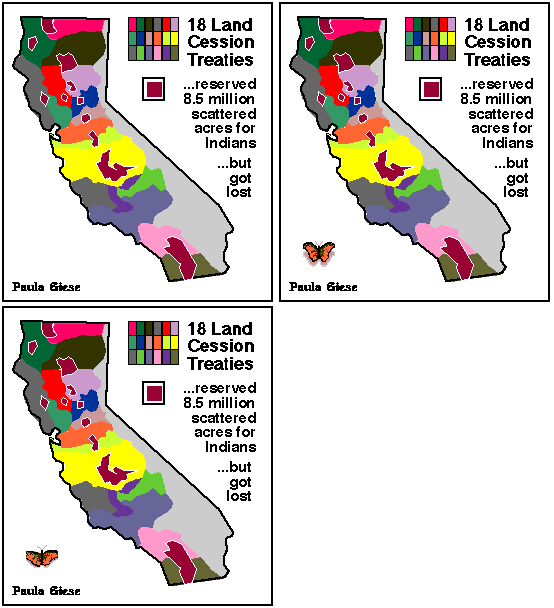
But the new citizens were needed for slaves, as assets of the squatters (oops, we mean pioneers) ...Opponents to negotiated treaties in the U.S. Senate "....saw a policy...deeply affecting the present and future prosperity of the State." "...they (treaty commissioners) have undertaken to assign to the Indian Tribes, a considerable portion of the richest of our mineral lands." "...gentlemen have undertaken to assign a considerable portion of the latter to the Indian tribes, wholly incapable, by habit or taste, of appreciating its value." (We must ask ourselves why indigenous Californians fought and struggled) "...they will...supply, to a great extent, what is so much needed, the labor, without which it will be long before California can feed herself." "To take any...country...west of the Sierra Nevada...for the home of the wild and generally hostile Indians...we claim an undoubted right...to remove all Indian tribes beyind(sic)...limits of the State..." Eighteen treaties were negotiated to secure legal title to public domain land and guaranteeing reserved lands and protection from white violence for indigenous Californians in 1851-1852. Here is a list of them, corresponding to the 18 sifferently-colored map areas. There is unfortunately insuficient info to connect each treaty to an area, making it an imagemap; that may be done later. Russ didn't provide a citation for the book from which he obtained his map originally.
A. Treaty of Camp Belt, May 13, 1851B. Treaty of Camp Keyes, May 13, 1851 C. Treaty of Camp Persifer F. Smith, June 10, 1851 D. Treaty of Dent's and Ventine's Crossing, May 28, 1851 E. Treaty of Camp Union, July 18, 1851 F. Treaty of Camp Bidwell, August 1, 1951 G. Treaty of Reading's Ranch, August 16, 1851 H. Treaty of Camp Colus, September 18, 1851 I. Treaty of Camp Cosumnes, September 18, 1851 J. Treaty of Temecula, January 5, 1852 K. Treaty of Santa Isabel, January 1, 1852 L. Treaty of Camp Fremont, March 19, 1851 (covered southern Costanoan territories) M. Treaty of Camp Barbour, April 29, 1851 N. Treaty of Lipayuma, August 20, 1851 0. Treaty at the Russian River (Camp Fernando Felix), August 22, 1951 P. Treaty of Lower Klamath, October 6, 1851 Q. Treaty of Upper Klamath, November 4, 1851
These treaties were never openly and publically debated (thus not appearing in the Congressional Record) and instead were hidden and remained so until discovered in the early 1900's, then denied. Meanwhile, indigenous Californians enjoyed the "protection" of the 1850 ACT which made slaves of them and turned life in the so-called land of the free into a horror, a travesty of the Constitution...the population of these people, about 200,000 -300,000 in 1848, was reduced to 15,238 by 1890. |
 In 1861-52 -- that is while the slaughters by American settlers, miners and the U.S. Army were just revving up on California natives -- a treaty commission was sent from Washington to get the indigenes out of the way of expansion into the newly-conquered (from Mexico) territory. They signed 18 treaties with more than 500 Indian leaders of the many tribes whose